Harlingen
The bunkers at Harlingen were part of the Atlantic Wall: the more than 6,000-kilometer-long German defense line from Norway to Spain. The Atlantic Wall is one of the largest structures of the 20th century.
The line was built during the Second World War between 1942 and 1945 to prevent an Allied invasion of the Western European mainland from the sea. The Atlantic Wall was a series of separate smaller and larger support points that could give each other fire support.
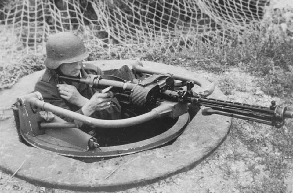
In many cases they consisted of bombproof bunkers, sometimes with a wall and roof thickness of at least two meters of reinforced concrete. Due to a lack of labour, equipment and fuel, only 510 bunkers of the planned 2000 had been built in the Netherlands. In the English Garden in Harlingen is a German bunker that was part of the Atlantic Wall. It concerns a Communications Command Post with which the Germans coordinated the Frisian coastal defences.
Here you will find Remains of the Atlantic Wall in Harlingen
Tuinpadfrom your location
On May 12, 1940, German troops entered the province of Friesland from Groningen and Frederiksoord-Noordwolde. The Wonsstelling,...
This walk through the city takes you past 13 information panels that document important events in Harlingen. The panels provide...
Harlingen is een echte schatkamer als het om monumenten gaat. In het centrum zijn prachtige voorbeelden te zien. Het 'gevaar'...
De zeeklei in de voormalige Friese streek Westergo is de rijke voedingsbodem van allerlei voedselproducten. Vruchtbare akkerbouw...
Wist je dat Harlingen een heel levendig en uniek centrum heeft? De historische binnenstad is een echte watersportbestemming....
Discover the rich cultural history of Harlingen along this sculpture trail. Set off in search of the most iconic sculptures...
This stage of the trail takes you through the vast no-man's land between the city of Harlingen and the village of Sexbierum....
Heb je slechts een middag, avond en ochtend te besteden aan je roadtrip? Bezoek de hoogtepunten van het Friese landschap...
Cycle along the coast of the UNESCO World Heritage Wadden Sea through various wadden villages and learn more about the life...
De Golf van Termunterzijl vertelt als Landmark geen eigen verhaal maar laat het landschap en bewoners hun verhaal vertellen. Bezoekers...
Termunterzijl
You cannot see this content because you haven’t accepted cookies. If you want to watch this video, please click below to accept cookies.
Manage cookies(beluister hier het audioverhaal)
Het is bijna niet voor te stellen dat de zee deze dijk kan verslaan. Toch was er in de laatste veertig jaar een keer of acht serieuze dijkbewaking nodig. Rinus en Sander Dorst van Zeedefensie zijn dan ook altijd voorbereid. Hier in de werkplaats hangen de zaklampen aan de muur, de portofoons staan aan de lader en ligt het draaiboek op tafel. Voor het geval dát.
Vader en zoon Dorst liggen er niet wakker van, ze weten namelijk precies hoe de dijk erbij ligt. Elke week inspecteren ze de 25 kilometer dijk tussen Harlingen en Nieuwebildtzijl. En elke dag zijn ze hier sowieso te vinden, voor onderhoud en beheer. Zo gooien ze bijvoorbeeld kuilen dicht die door honden zijn gegraven en vangen ze ongeveer 150 mollen per jaar in hun klemmen.
Is dat nou echt nodig? Ja, want gangen, gaten en kuilen kunnen de dijk behoorlijk verzwakken. Ook is de grasmat superbelangrijk om de bovenlaag sterk te houden, hiervoor wordt een mengsel van zes soorten diepwortelend gras gebruikt. Als 80% van een vierkante meter grasmat ook daadwerkelijk uit grassprietjes bestaat, zijn de mannen dik tevreden.
Het gras wordt onderhouden door de schapen die je tussen april en oktober op de dijk ziet grazen. Met hun 'gouden voetjes' trappen ze de grond precies genoeg in en zorgen ze zo voor de ideale stevigheid. Vroeger graasden er ook wel koeien, maar hun hoeven deden meer kwaad dan goed.
De droogte van de laatste zomers baart wel eens zorgen. Schapen hebben soms nauwelijks genoeg te eten en enkele dijkvakken moesten opnieuw ingezaaid worden. Ook zette het waterschap voor het eerst een egger in, een machine die onkruid uit het gras haalt.
Andere soorten grassen en kruiden op de dijk zouden trouwens best een idee zijn, maar of dat veilig is? De proefvakken die je onderweg zag, laten vooralsnog zien dat de combinatie van schapen en gras het beste is voor de stevigheid van de dijk.
Aan de 'achterkant' van de dijk vind je geen gras maar asfalt, met daaronder steen en zand. In de jaren negentig bleek het asfalt zo zwak dat uit voorzorg breuksteen en grond bij de werkplaats is neergelegd. Je weet immers maar nooit. Intussen wordt er ook een proef gedaan met innovatieve asfaltbekleding.
Ingesproken door:
De van oorsprong Friese Esther Kokmeijer is kunstenares, ontdekker, designer and fotograaf. Ze woont tegenwoordig in Rotterdam, maar werkt overal ter wereld.
Esther werkt met Joop Mulder aan een serie projecten waarmee ze met korenbloemen verhalen over water zichtbaar wil maken. Een zee van bloemen, een terp omringd door water, een dijkdoorbraak en Holwerd aan zee, zichtbaar gemaakt met miljoenen bloeiende Korenbloemen. “Inspirerend hoe Joop zo begaan was met het prachtig Waddengebied. Hoe hij verhalen over dit bijzondere landschap tot leven wist te brengen en zich inzette om intieme ontmoetingen te creëren met dit landschap.”
Dit verhaal is onderdeel van de route Gemalen Verhalen van Sense of Place
Het is bijna niet voor te stellen dat de zee deze dijk kan verslaan. Toch was er in de laatste veertig jaar een keer of acht...
Boonweg
Sint Jacobiparochie
De bebouwde kom van Appingedam was maandagmorgen 23 april 1945 waarschijnlijk rond de klok van tien uur helemaal bevrijd.
Wijkstraat 36
9901 AT Appingedam
You cannot see this content because you haven’t accepted cookies. If you want to watch this video, please click below to accept cookies.
Manage cookies(beluister hier het audioverhaal)
Strandhuis der Bildtpollen. Het staat er echt, op de woning hier aan de voet van de Nieuwebildtdijk. Een schelp siert het wapen op de gevel. Maar waar is het strand dan? Helaas. Zwemmen of recreëren kun je hier niet, maar strand betekent dan ook eigenlijk gewoon de overgang tussen land en zee.
Dit strandhuis werd in 1899 gebouwd voor het waterschap De Bildtpollen. Die Bildtpollen liggen hier achter je. Sinds 1715 is het een smalle polder van in totaal 55 hectare groot, die reikt tot aan het Noarderleech in het oosten.
Het waterschap van de Bildtpollen vergaderde eerder in de voorganger van dit huis, dat contributiehuis werd genoemd. En er waren nog twee andere strandhuizen op het Bildt, met hun eigen waterschap en strandmeester. Het statige Hooghuis aan de dijk tussen de Boonweg en Zwarte Haan moest in de jaren zeventig van de vorige eeuw verdwijnen voor de dijkverhoging, het strandhuis bij Westhoek is onherkenbaar.
De strandmeester van de Bildtpollen, die hier met zijn gezin woonde, voerde het dagelijkse werk voor het waterschap uit. Dat betekende vooral toezicht houden op de dijk, maar ook vaarten en weggetjes onderhouden die belangrijk waren voor de waterhuishouding, personeel aansturen en vee verzorgen dat in de polder graasde. De schuur stond vol met spullen voor dijkonderhoud en dijkbewaking.
De volmachten, bestuursleden wier gezichten op schilderijen en foto's zijn vereeuwigd, vergaderden altijd in de bovenkamer. Hier hadden ze goed zicht op zee en de (toen nog lagere) dijk een kilometer verderop. Soms sloten ook de 'ingelanden' bij de vergaderingen aan, eigenaren van de grond die tegen de zee beschermd moest worden. De vrouw des huizes kwam regelmatig met een dienblad de steile trap op om de heren met koffie, sigaren en sterke drank te bedienen.
Heerco Spoelstra was de laatste strandmeester. Toen het huis na fusies van waterschappen in 1980 vrijkwam, kochten de huidige bewoners het op een veiling. De eerste nacht dat het stormde, was het overduidelijk hoe zeer de wind hier de baas is. Toch hebben ze geen minuut spijt gehad.
Ingesproken door:
Arjen Boerstra creëert installaties, video’s, foto’s en voorstellingen op specifieke plekken. Daarbij staat de vraag ‘Wie of wat ben ik?’ centraal. Zijn werk toont in scene gezette situaties en vertelt verhalen over herinneringen, identiteit en menselijke ontwikkeling.
Oerol 2007 was het begin van een lange samenwerking tussen Arjen en Joop Mulder. Van het project De Aardappeleter tot Camera Batavia. “Als ik met Joop op stap was, maar ook als ik aan Joop denk, dan ging en ga ik opeens beter kijken. Uit opportunisme want ik wil projecten doen in dat landschap, maar ook uit een gedeelde liefde om verhalen te vertellen en ogen te openen. Dat delen en bewust maken was bij hem altijd voelbaar, het was waarvoor hij streed en waarmee hij tomeloos doorging.”
Dit verhaal is onderdeel van de route Gemalen Verhalen van Sense of Place
Strandhuis der Bildtpollen. Het staat er echt, op de woning hier aan de voet van de Nieuwebildtdijk.
Schuringaweg 63
9076 GS Sint Annaparochie
In response to the air raids on London and other places, the British government ordered the bombing of German cities and...
Begraafplaatslaan 1
Harlingen
Op de dijk is een monument aangebracht ter nagedachtenis. Een opmerkelijke bijkomstigheid is dat het vliegtuig maar 27 uur...
Nieuwe Zeedijk
Holwerd
De Arumer Groenedijk is een dwarsdijk gelegen in de Marneslenk, waarmee een gedeelte van deze slenk werd ingepolderd.
Groene Dijk
8822 Kimswerd
Al in de 11de eeuw vestigden zich hier boeren op kleine wierden in de vruchtbare Fivelboezem. In de 13de en 14de eeuw werden...
Oldenzijl
De internationale cruiseschepen en riviercruises die Harlingen aandoen, bieden een prachtig schouwspel. Kom kijken!
Nieuwe Willemshaven 10
8861 AA Harlingen
Door de breedte en de schuine oevers is de Ringsloot een geliefde plek voor meerkoeten en eenden. Ook watersnippen en groenpootruiters...
Ringsloot
Oosterboutenweg
Terschelling
Subscribe to our monthly newsletter to get all the latest tips, arrangements and news about the Wadden.